
Good morning, RVA: 757↗️ • 19↘️; a correction; and lots of nerdy urbanism
Good Morning, RVA!
English - September 15, 2020 12:21 - 10.7 MB - ★★★★★ - 48 ratingsNews Homepage Download Apple Podcasts Google Podcasts Overcast Castro Pocket Casts RSS feed
Good morning, RVA! It’s 59 °F, and today you should expect highs in the mid 70s. That’s shockingly fall-like, and I hope you take the time to enjoy it.
Water cooler
The Richmond Police Department reports that Jeremiah Darden, Jr., a man in his 20s, was shot and killed this past Friday on the 00 block of E. Blake Lane near the intersection of Hull Street and E. Broad Rock Road. Police are asking anyone traveling in the area around 12:00 AM to contact detectives (804.780.1000).
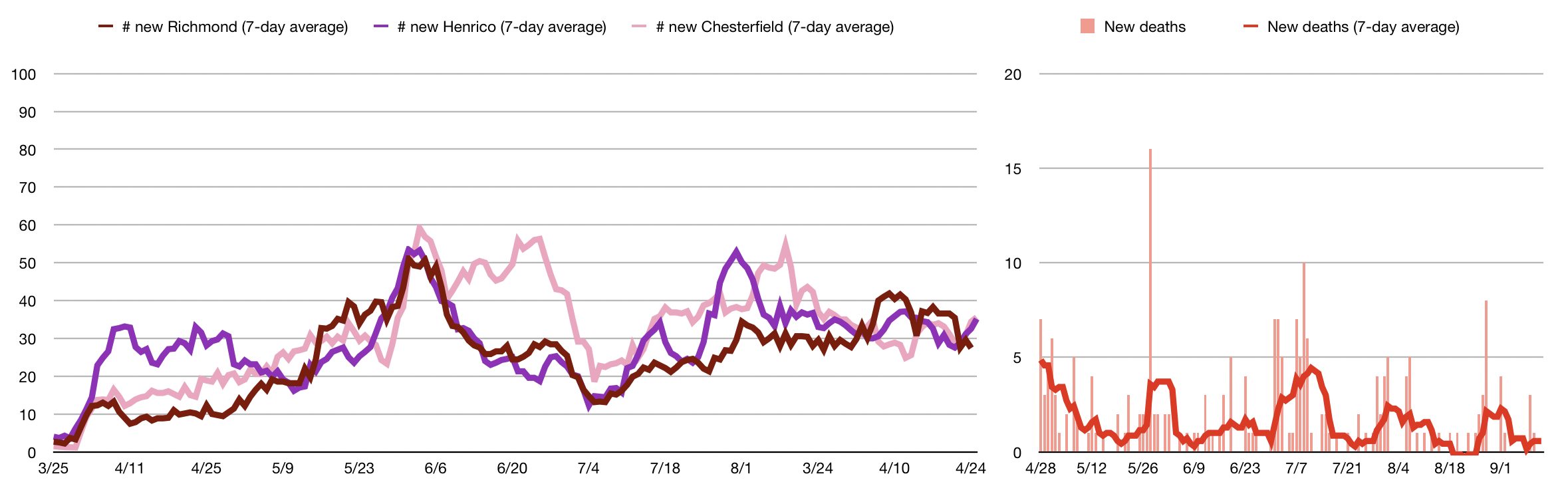
As of this morning, the Virginia Department of Health reports 757↗️ new positive cases of the coronavirus in the Commonwealthand 19↘️ new deaths as a result of the virus. VDH reports 68↗️ new cases in and around Richmond (Chesterfield: 18, Henrico: 31, and Richmond: 19). Since this pandemic began, 334 people have died in the Richmond region. Astute readers will notice the big drop in new cases in our region—particularly in Henrico. Turns out, that’s not a drop at all, but me correcting a pretty severe typo in my coronacounts spreadsheet! At some point, my spreadsheet started adding Richmond’s new case count to Henrico’s new case count, and that sent the County’s numbers skyrocketing (comparatively). I should have noticed this earlier, but, unfortunately, it took two readers emailing me yesterday asking what the heck was going on in Henrico to send me poking through my spreadsheet forumlas. Here’s a corrected graph of the seven-day average of new regional case counts, which, while not great, no longer paints Henrico as a horrible outlier. To help prevent this sort of casual-yet-catastrophic error in the future, I’m going to attempt to move my coronacounts spreadsheet to a public Google Sheet. That way other folks can poke around in the formulas should they so desire. Anyway, sorry about that!
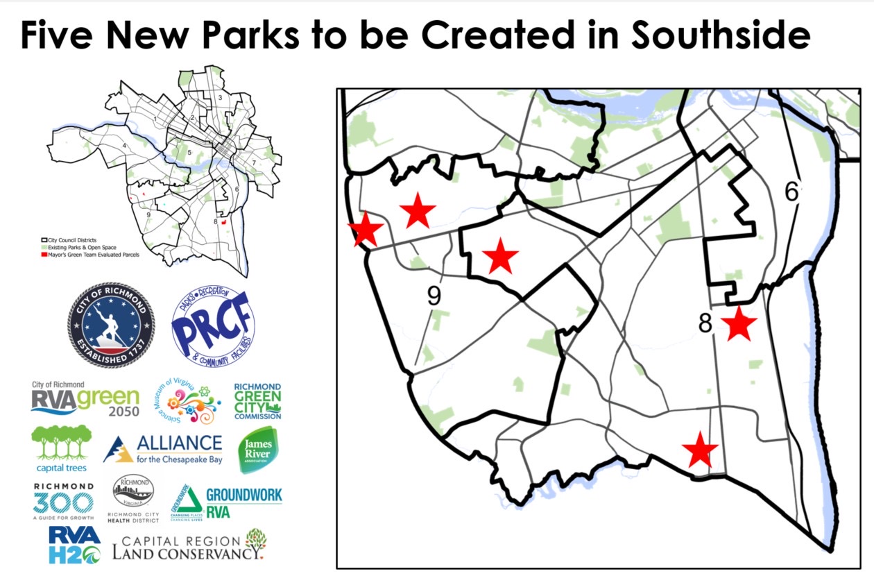
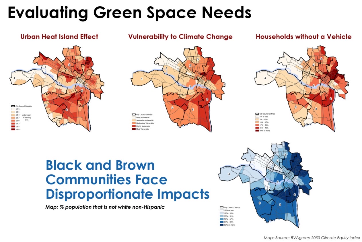
Yesterday, Mayor Stoney announced that the City will convert 36 acres of unused city-owned land into public green spaces. That’s five parcels, all located on the Southside, with three in the 8th District and two in the 9th District. Here’s a map of the locations, or, if you really care, you can look at the property details on the City’s Property Search website (1, 2, 3, 4, 5). Another cool thing about this announcement is that the City used the RVAgreen 2050 Climate Equity Index to figure out where to locate all this new green space. I’m going to link to this Climate Equity Index interactive map, which presumably explains it all, but it is too intense for my iPad to load—so who even knows what you’ll find should you click that link. For the rest of us, here are some jpg maps that illustrate the kinds of things the Climate Equity Index takes into account. You can easily see how it makes a lot of sense to focus the creation of new public green space on the City’s Southside. Up next: The Mayor will introduce the ordinance to get things moving at the September 28th Council meeting, and then Parks & Rec will start engaging with communities around the parcels to begin designing the spaces.
Speaking of RVAgreen, there are lots of ways for you to get involved in the City’s “equity-centered climate action and resilience planning initiative.” I really enjoy their Get Involved page which gives you a bunch of different options based on the amount of time you’ve got to spend—from signing up for email updates (one minute), to taking a community survey (10 minutes), to applying to join the Racial and Environmental Justice Roundtable (3–5 hours per month).
Nerdy urbanism topics abound today! Richmond 300, the City’s Master Planning process, has released their “pre-final plan”. Probably what you’re after is this memo documenting revisions between June 1st and now (PDF). One of the bigger changes is the addition of a new land use category called “community mixed-use,” which appears to allow for more density than “neighborhood mixed-use” but not as much density as “corridor mixed-use.” Is this splitting hairs? I have no idea, but I imagine the process/conversation behind making this particular decision was…interesting…and I’d love to hear more. Anyway, as far as I’m concerned there’s still too much of the residential category on the Future Land Use map, particularly in parts of the Northside and West End. This kind of conservative planning only makes reaching our housing goals that much harder and removes much of the burden of More Housing™ from those aforementioned neighborhoods. I’m sure, as with everything, you could do some interesting overlays with the red lining map. Also of note, Objective 8.4 “Increase transit service” has been changed to add a clear goal: “serve existing and new riders so that 75% of residents live within a half mile of a transit line with service that comes every 15 minutes by 2040.” Love it.
You thought we were done with nerdy PDFs and dashboards? THINK AGAIN. At some point, VDOT put together this really interesting pandemictimes Virginia Commuter Survey and the results of the first round are out. Surprise: Lots of folks are working from home! That’s not surprising, but, maybe actually surprising: 37% of respondents who are currently commuting via bicycle switched from a different mode. Make sure you check out the three dashboards and quench whatever early-morning desire for data you may have.
As one of the only public school systems in the region doing in-person instruction, it’s fascinating to watch Hanover County deal with positive coronavirus cases. Abby Church at the Richmond Times-Dispatch says Kersey Creek Elementary school in Hanover will move to remote instruction after a teacher tested positive. It’s interesting (and maybe predictive?) that the County decided to move the entire school to remote instruction rather than just the class. Keep that in mind as other schools start to move back to some sort of in-person instruction. Like, for example, the RTD’s Jessica Nocera reports that “select K–12 special education students are heading back into Chesterfield County public school classrooms at the end of the month.” Other groups of students will tentatively return over the course of a couple weeks, with 6th–12th graders returning to a hybrid in-person instruction model by November 9th. Personal opinion, this seems complex: “Cohorts 2–4 will return to school twice a week and will be split by last name. For example, Group 1 of any cohort is students with last names that begin with A through L. These students would attend school Monday and Tuesday. Group 2 of any cohort is students with last names that start with M through Z, and they will attend Thursday and Friday. Every Wednesday, schools will be closed for cleaning with all cohorts participating in asynchronous learning.” Better hope everyone in your family has the same last name, I guess!
This morning’s longread
The weird space that lies outside our Solar System
Space is just so, so neat, and the Voyager probes are some of our coolest things. Good work, humans.
Voyager 1, which took a more direct route through the Solar System, passed out into interstellar space in 2012, before Voyager 2 joined it in 2018. Currently around 13 billion and 11 billion miles from Earth respectively, they are now drifting out, ever further into the space beyond our Solar System, sending back more data as they do. What these two aging probes revealed about the boundary between the heliosphere and the interstellar medium has provided fresh clues about how our Solar System formed, and how life on Earth is even possible. Far from being a distinct boundary, the very edge of our Solar System actually churns with roiling magnetic fields, clashing stellar windstorms, storms of high energy particles and swirling radiation.
If you’d like your longread to show up here, go chip in a couple bucks on the ol’ Patreon.